Certainly ! I wouldn’t have asked this question if my photos weren’t geotagged 
But thank you for your answer …
1 Like
It doesn’t work either on Big Sur 
I feel less alone…
Thank you for answer.
I find that the function needs a toolbar icon - at least when we can also add coordinated through the map.
@Joachim If you show the Metadata palette in PhotoLibrary you will see the map icon, so it is available in both modes of PL.
1 Like
In this context I want to link to my old suggestion:
https://forum.dxo.com/t/pl5-0-ea-7-win-improved-selective-copy-paste-of-metadata/20301/3?u=wilsberg
If I right-click in the google map on a position, I can copy the coordinates in one step: “XX.41298751081041, Y.929338014939609”, if I would have in PL a possibility to copy it in one menu to separate the coordinates than it would be very easy to get geotagged pictures.
Thank you, I missed that.
Hi there,
Can you confirm the following please?
• You have a picture with valid GPS coordinates (at least latitude and longitude)
• You see the “map” icon next to the Latitude input field
• You click on it and nothing happens
Thanks
Steven.
There is at least one blind spot: The map icon goes grey…
The option is inactive (AKA the icon is greyed out) if there are no coordinates…
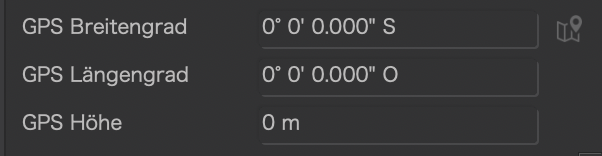
Yes but the GPS coordinates 0,0 exists 
Show me first a picture taken exactly where Latitute and Longitude intersect 
As soon as I find a boat 
You’ll also need a very precise positioning instrument, not sure it’s even available for civilians…
Seen like that, we will say that the probability is zero.
My boss would tell me, if the probability exists even tiny, we must anticipate, we will not come back later.
1 Like
Not zero, rather close to 
So, are you saying that non-civilians are excluded from the target market for PL?
1 Like
When I took an image that had GPS coordinates set (externally using Geosetter) and then altered them to 0, 0, 0 (Longitude, Latitude and Altitude) the “See on map” remained active (i.e. not greyed out) and selecting in resulted in a Google Maps display as expected (the Atlantic Ocean, south of Ghana and west of Gabon).
…well, somehow, DxO’s geolocation UI is a arthropodarium
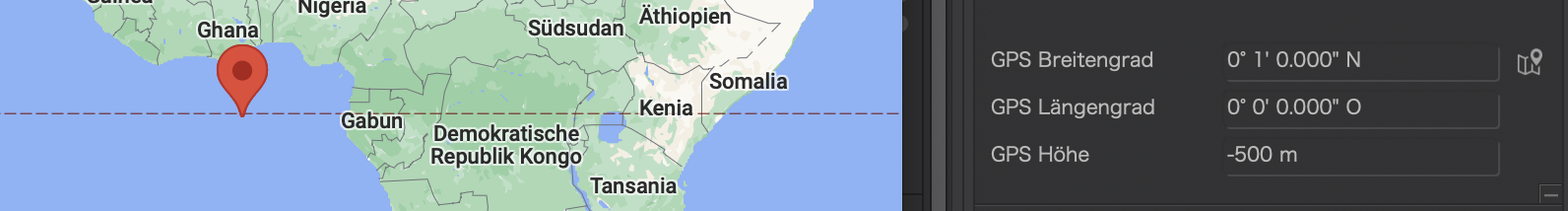
(not sure how deep the ocean is at those coordinates)
Excluding “0” is one of the most basic programmer’s errors 
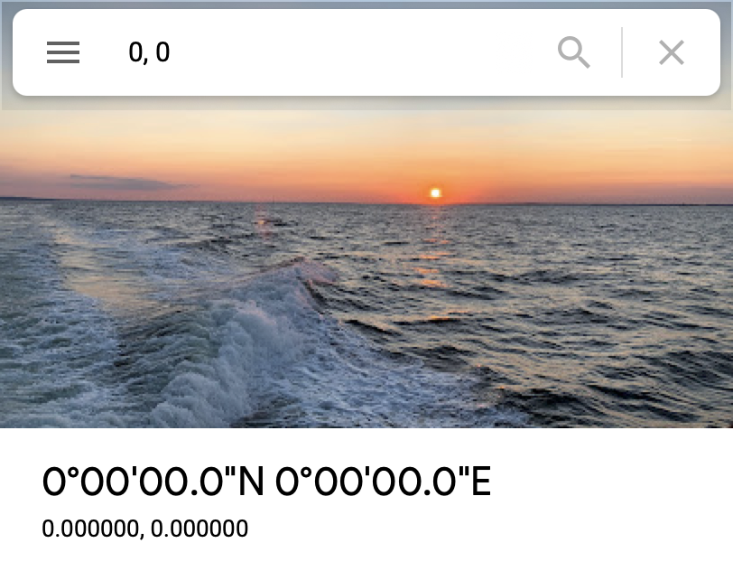
Google can do (or fake) it:
1 Like
I was able to enter 0 for altitude, and after navigating away to another image and back to the image the metadata display still shows 0m. This on the Windows version of PL5.